Mapping Tools
Mapping Tools
MyMaps
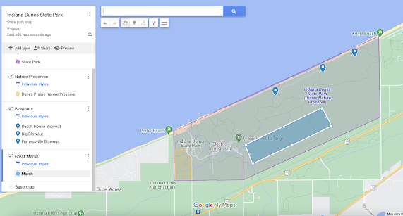
The first online map system I tried was MyMaps from Google. This map system was very easy to understand and is user friendly. I found my area using the search button. Then I added layers that contain lines or polygons and labelled all of them. I can see this tool being useful to pinpoint where you have gone and any features you want to remember on a trip. I really like seeing each step I have done. I, also, like how I can make the polygons different colors. The best part of this is that it was free.
Source: Screenshot of MyMaps
ArcGIS
The second map system I used was ArcGIS online. This system has the same user friendliness. The system gives you promotes throughout the parts. I played with the system for a while before making this screenshot. I could not figure out how to make the polygons different colors or how I can't see the different steps that I have done. I do like how easy it is to make points and labels. This would be nice to use but it is costly and not everyone.
Source: Screenshot of ArcGIS
ArcGIS. (2022). Indiana Dunes State Park ArcGIS [Screenshot of map made of Indiana Dunes State Park from ArcGIS]. Retrieved from https://hiw.maps.arcgis.com/home/webmap/viewer.html?useExisting=1
MyMaps. (2022). Indiana Dunes State Park MyMaps [Screenshot of the map made of Indiana Dunes State Park from MyMaps of Google]. Retrieved from https://www.google.com/maps/d/u/0/edit?mid=1e9M9wivVCgDLNL7bgkvIqvbj08qRycc&ll=41.66651025515728%2C-87.03878255000002&z=14


Comments
Post a Comment